
Re. Texas lands information
What is owned – It is an undivided interest in ownership of two sets of “rights” over lands within Pecos County Texas. These rights are either Mineral Rights only or both Surface and Mineral Rights on a total of about 8281 acres bordering on the south bank of the Pecos River.
NOTE: You all probably know what “undivided interest” is but for those who don’t, I give you the following description. These surface and mineral Ownership Rights are such that everyone owns a piece of the "value" of the same acres. It's sort of like owning stock in a company. Say there was a mythical company named "C J Price Lands Co." with a fixed number of 100 stock shares. Within the "Company” there are three major groups of "stockholders", the Price, Miller, and McClintock groups... The "Price Group" owns 4/8ths or 50% (50 "shares") of this mythical company, the Millers owns 3/8ths (37.5 shares), and the McClintocks own the final 1/8ths (12.5 shares) of the "Company". In the "Price Group", Ruth Mary, Cindel, Anna, and Elsie, have 10 shares each, Dennie holds 5 shares, and Betsy, William, and James hold 1 and 2/3 share each. Each shareholder is entitled to any income the mythical company earns based on the number of “shares” they hold. And, like stock shares in a real company, any shareholder may sell their shares or, if another "stockholder" is selling, buy those shares in the mythical "C J Price Lands Co". And these shares or fractions of shares can be passed on to heirs.
.
Below is an image of the total (both mineral only and mineral & surface rights) lands.
The total Price lands encompass all or part of the land blocks numbered 2 thru 18 in the above picture that lay directly south of and bordering on the Pecos River – The squiggly SE-NW line in the middle of the image. The Surface Rights acreage covers most of the 5 blocks farthest west (to the left).
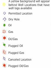
The wells as shown as colored dots are a mix of active (gas, oil or both) and abandoned, shut, plugged, etc wells. The green lines are pipelines.
Taxes: Also enclosed in the packet is information on how Pecos County has assigned ownership for tax purposes of the land where Surface Rights are held by members of the Price group. Each of the 3 major groups or their group members (where the groups have no one point of contact) are treated the same based on the percentage of undivided interest they hold. The parcel numbers Do Not represent a specific, wholly owned piece of ground belonging to the individual, they are only for accounting for the partial ownership of the whole, larger piece. Each Owner has their own county ID number and a set of parcel numbers assigned to their interest holding.
NOTE: Question: What happens if an interest owner does not pay their ad valorem (property) taxes? Answer: A Pecos County employee stated to me over the phone that, before taking further action, the taxing authority would notify the other interest owners that Interest Owner So-in-So has not paid. (I am waiting for confirmation on this). Then, if the tax bill continues unpaid, that specific Owner Interest is put up for sale by the county just as in any tax sale scenario.
NOTE: In the case of Mineral Taxes, basically the State withholds future income until the bill is paid. All other Interest Owners are unaffected by the action (or inaction) of one.
Income: This is the big one! - Grin
This website has a link to an Excel Spreadsheet (titled Income Spreadsheet), one worksheet covers Owner info, one sheet (titled Active leases) is a breakdown/compilation/whatever of the currently active sources of income from oil and gas production., the remaining two sheets have contact information for involved companies.
NOTE. Each Royalty recipient is issued a specific ID by each particular Royalty Payor / Company – It is on each Division Order and it is also shown on the information sheet that comes with each check – usually on the left side. If you wish to contact any of the companies, they will want to know that ID. Some of the companies offer direct deposits - see the lower right of the Co. contact sheet.
The Leases sheet - What I did was to go through what information I had from Tom Scott, the information on the new division orders to the Price Group members, and the information on each of the Royalty checks Cindel has received to date, then correlated or expanded the data based on information from the Texas Railroad Commission databases available on the web. All while taking a self directed crash course in the oil and gas business. – Something not for the faint of heart – trust me…
Bottom line to date: With the exception of the Sunoco payments (highlighted in yellow) of which I am still working on. I have compared the company’s well identifications / production figures noted on the checks with what is reported to the State of Texas and they seem to match as to volumes of product. – A good sign...
The Checks: The Company signing the royalty checks may be the operator, the company buying the product or just a third party contractor. - We have some of all three signing our checks. Each check can cover multiple wells and / or leases
Now to explain the other data on the “Leases” form.
RRC means the Texas State Railroad Commission – the state regulatory authority for oil & gas wells.
Each specific hole in the ground has one specific API number, the only other absolute relationship that is that each specific hole has one operator at a time.
The well operator is generally responsible for “keeping the books”
Division Orders can cover multiple Leases.
Individual Leases can be serviced by multiple Companies / Division Orders.
Each specific hole in the ground may have multiple “wells”
Gas leases: They cover Natural Gas and Condensate Oil.
1. Each Gas Lease covers a specific hole in the ground as identified by a particular API number.
2. A particular hole in the ground may have more than one Gas Lease.
Oil Leases: They cover Oil and Casinghead Gas
1. Each Oil Lease can cover more than one hole in the ground (multiple API numbers)
2. Each particular hole can have multiple Oil leases
A particular hole in the ground (single API number) can have both multiple Oil and / or Gas leases
A company’s well identification ID and well name most likely does not match the name and ID assigned by the State.
In Summary : 13 active paying leases.
13 active holes in the ground (not a 1 to 1 relation with the Leases)
15 active “wells”
5 active ‘Operators”
And 7 companies sending Royalty checks.
What remains: I am continuing to research other wells and oil and gas leases that do exist – so far the wells are reported as abandoned, plugged or shutdown. And the other leases show no reported production to the RRC. However there are some discrepancies and things like injection wells which I am investigating. I also have very little info on right of ways/easements or similar situations. And nothing on the grazing leases income. And, we need to put in a new grazing lease
I am also working on possibly getting a local Landman / agent to be our eyes and ears locally.
Mike
My background – 30+ years with U.S. Coast Guard as a marine science tech and then middle management, with stints in Oil Pollution Investigations, Marine Casualty Investigations and Commercial Vessel Inspections, (and for couple of years out of the CG in the 1970’s) as a Real Estate Appraiser in Fl. After the USCG gig, in 2002, I went back to school and received my BS (the initials can stand for a couple of things) degree in Information Management. Along the journey I also became sort of obsessive (read anal) when it comes to compiling information / Data – grin